
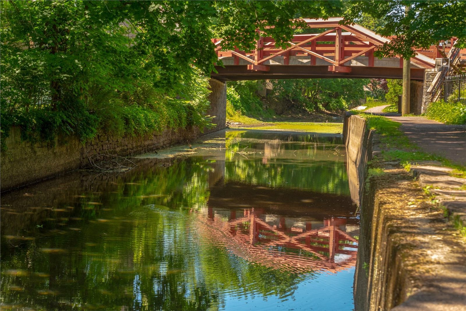
The Delaware Canal towpath near New Hope, Pennsylvania
Nature in & around New Hope

Sixty miles of trail. Two state parks. One river.

A canal towpath out the back door, a wildflower preserve, an observation tower, hidden swimming holes, and the Delaware itself. Pick a season and pick a direction.

🚴
The headline

The Delaware Canal Towpath.

This is the headline. The Delaware Canal State Park runs sixty miles along the Pennsylvania bank of the river, all the way from Easton in the north to Bristol on tidewater in the south. The crushed-stone towpath is mostly flat, mostly shaded, dog-friendly, stroller-friendly, and free. The trailhead behind the New Hope Visitor Center on Mechanic Street puts you on it in under two minutes.

You don't have to walk far for it to be worth it. 15 minutes south brings you to the New Hope locks (Locks 7, 8, and 9), where the canal drops about 28 feet over three quarters of a mile and the original 1830s lock houses are still standing. 45 minutes south puts you at Phillips Mill, a stone hamlet from the 1750s with a covered footbridge over Pidcock Creek.

Heading north is just as good. Walk an hour and you're at Centre Bridge. A little over two and you're in Lumberville, where the General Store has been running since 1770 and a pedestrian footbridge crosses the river to Bull’s Island.

A National Historic Landmark, and the only surviving canal of the early American canal era still in its original alignment. A little of that is in your bones every step you take.
Trailhead: behind the New Hope Visitor Center, 1 W. Mechanic Street. Free parking on weekdays. Watch out for cyclists; the towpath is shared.
🌿
134 acres of native plants

Bowman’s Hill Wildflower Preserve.

About 4 miles south of the borough on River Road, sitting on the slopes that rise out of the Delaware floodplain, is Bowman’s Hill Wildflower Preserve. It's 134 acres of native Pennsylvania plants, and it's one of the oldest preserves of its kind in the country, established in 1934 as part of Washington Crossing Historic Park. 8 named trails wind through woodland, meadow, pond, and bog habitats. About 1,000 species of native plant on the property, more than half of them documented by trained volunteers.

Spring is the headline season. Trillium and bloodroot in early April. Native phlox and Virginia bluebells through April and May. The native azaleas, mountain laurel, and rhododendron run from May through June. Summer brings native sunflowers and wild bergamot, and fall is the second peak with goldenrod, asters, and the leaves on the hardwood ridges.

The Headquarters Trail is paved and accessible. The other seven trails are natural surface, mostly easy. Trained volunteers lead guided walks every weekend, and free informally guided walks during the spring and fall peaks. The visitor center has a small bookstore, a gift shop, and a native plants nursery that sells species suitable for backyard gardens.

Address: 1635 River Road, New Hope. Open year-round, dawn to dusk. Modest admission fee. bhwp.org
🗽
125 feet up

Bowman’s Hill Tower.

About a mile south of the wildflower preserve, on the hilltop in Washington Crossing Historic Park, sits a 125-foot stone observation tower. Finished in 1930 to commemorate the Continental Army camping on this hill in late December 1776, in the days before the famous crossing of the Delaware. Climb the spiral stair (or take the small elevator if it's running) and on a clear day you can see across the river into New Jersey, north toward New Hope, and south toward the great bend of the river above Yardley. There's no better single view of the New Hope landscape.

Where: Washington Crossing Historic Park, off Route 32. Modest fee to climb the tower. Open seasonally; check before you go.
🌊
Free, public, full of things to do

The Delaware River.

The river is the reason the town exists. It's also free, public, and full of things to do. A non-exhaustive list:

  • Tubing. Several tubing companies on the New Jersey side and just upriver run guided floats from late spring through early fall. The classic float is from Point Pleasant down past New Hope. Three to five hours on the water depending on flow.
  • Kayaking and canoeing. The river is gentle in this stretch, suitable for moderately experienced paddlers. The boat launch at Lambertville (across the bridge) is the closest free put-in. Outfitters in Point Pleasant rent boats.
  • Fishing. Smallmouth bass year round with a Pennsylvania fishing license. American shad in spring, generally late April to early May. Catfish, pickerel, and the occasional striper. The riffles north of New Hope are productive; ask at the visitor center for a tip.
  • Birding. Bald eagles nest on both banks of the river. Great blue herons hunt in the shallows. Osprey are common in summer. Migrating warblers come through in May and September.
  • Just looking. The middle of the New Hope Lambertville bridge is the best free perch in the borough. Sunset on a clear day is its own event. Bring a friend.

Swimming in the river is at your own risk. The current can be deceptive, water levels vary, and the bottom is uneven. Locals know which spots are safer than others. The official guidance is that there's no designated swimming on the New Hope reach.

🇺🇸
Where the river turned the war

Washington Crossing Historic Park.

Washington Crossing Historic Park is the Pennsylvania state park six miles south of the borough that preserves the spot where Washington and the Continental Army crossed the Delaware on the night of December 25 to 26, 1776. The park is split into two sections, the lower park at the actual embarkation point on the river and the upper park up at Bowman’s Hill.

Beyond the historical aspect, the park has a network of woodland trails through the river-bend forest, picnic groves along the water, a small ranger-staffed nature center, and a beautiful early American village of restored buildings including the McConkey’s Ferry Inn from the 1750s. Every December 25 the state runs a full reenactment of the crossing with period costume, period boats, and the actual river. It draws a crowd. Worth the drive any time of year.

Address: 1112 River Road, Washington Crossing, PA. Free; small fee for the historic buildings. Trails open dawn to dusk.
🌮
A quiet pond and meadow

Aquetong Spring Park.

A few minutes outside the borough off Aquetong Road in Solebury Township, Aquetong Spring Park protects what was once one of the largest natural springs in the region. The spring fed New Hope’s mills for two centuries; an old millpond and dam are still there, breached now and slowly returning to a wetland. The park is small, about 60 acres, with quiet walking loops, a pond ringed by tall grass, and a meadow that's good for spotting birds at dusk. Mostly local people use it. It's rarely crowded.

Where: Aquetong Road, Solebury, about two miles north of the borough. Free.
⛰
Worth the drive north

Tinicum & Ralph Stover.

For a longer outing, drive 30 to 40 minutes north along Route 32 (River Road) and you reach two of the better state and county parks in the region.

Tinicum County Park sits on a wide bend in the Delaware near Erwinna. 500 acres of riverfront with picnic groves, a covered bridge (Erwinna Covered Bridge, the shortest covered bridge in Bucks County, built 1832), trail access to the canal towpath, an outdoor stage that hosts summer concerts, and the historic Tinicum Mansion. Formal gardens, sycamore-shaded lawns, and one of the best free picnic spots in the county.

Ralph Stover State Park is a few more miles north, set above Tohickon Creek. The headline at Stover is High Rocks, a 200-foot dolomite cliff that rises straight up out of the creek. It's one of the few free rock-climbing destinations in eastern Pennsylvania. For non-climbers, the overlook trail to the top of the cliff is short and the view is worth it.

🗺️
Long-distance hiking

The Highlands Trail.

The Highlands Trail, a long-distance path running from the Hudson River in New York to the Delaware Water Gap and now extending south, passes through the Bucks County highlands just north of New Hope. Signed access points along Pidcock Creek Road and at Bowman’s Hill. Day hikes range from short 2-mile loops to ambitious all-day stretches. The trail tends to be lightly used and the views from the ridges are the best in the area.

🌚
The pretty back roads

Solebury & the back roads.

Drive (or bike) any of the unsigned local lanes that run inland from the river above New Hope, especially Phillips Mill Road, Aquetong Road, Lurgan Road, Mechanicsville Road, and Fleecydale Road, and you're in some of the prettiest farmland in southeastern Pennsylvania. Stone houses from the 1700s and 1800s. Working horse farms. Old red barns. Drystone walls.

There's no better 30-mile aimless drive in this part of the country. Bring a paper map; cell signal comes and goes. Most of the prettiest stretches aren't signed and are easy to miss.

🐦
A serious flyway

Birding hotspots.

Bucks County is a serious birding region. The Delaware River corridor is one of the major flyway routes for warblers, raptors, and waterfowl. Some of the best free spots within 15 minutes of the borough:

  • The canal towpath at sunrise. Especially during May and September migration. Wood thrushes, ovenbirds, scarlet tanagers, indigo buntings, all the warblers.
  • Bowman’s Hill Wildflower Preserve. Resident populations of pileated woodpeckers, barred owls, and a half dozen warbler species. The preserve runs guided birding walks each spring.
  • Aquetong Spring Park. Wood ducks, great blue herons, kingfishers, and migrating swallows over the pond.
  • Washington Crossing Historic Park lower section. Bald eagles roost in the floodplain trees year round. Look up.
  • The Delaware River from the bridge. Cormorants, common mergansers in winter, and the occasional bald eagle hunting fish off the water.
🎣
Smallmouth, shad, the occasional striper

Fishing the Delaware.

The reach of the Delaware between Lambertville and Centre Bridge is one of the better smallmouth bass streams in eastern Pennsylvania. The riffles at Wells Falls, just upriver from New Hope, are productive year round. American shad run up the river in late April and early May, and during the run there's a fairly serious shad fishery from the banks and from kayaks.

The Pennsylvania Fish and Boat Commission requires a state license; day passes are sold online. Bring spinning gear or a fly rod. Local bait shops in Yardley and Frenchtown stock what you need.

🚴
Sixty paved miles, almost no grade

Cycling.

The towpath itself is the great rail-trail style bike route in the region. 60 paved miles, almost no grade, very little car traffic. The Delaware River Trail is also nearing completion on the New Jersey side, connecting Washington Crossing to Frenchtown via a parallel rail-trail conversion. Both make for strong half-day or all-day rides.

The roads of Solebury are quieter than most weekend cycling roads anywhere near a major city, with rolling terrain and the kind of scenery that makes you want to stop every 20 minutes.

🌲
When to come

In every season.

Spring is the showcase. Wildflowers at Bowman’s Hill, dogwoods and redbuds along the towpath, the river running high and clean from snow melt. Birds are loud and visible. Tick season is just starting.

Summer is for the river. Tubing, kayaking, swimming in the creeks (Tohickon and Pidcock have legal swim spots when water is up). The towpath stays cool on hot days because the canopy holds.

Fall is the second peak. The Bucks County hills run red and orange from the third week of October through the first week of November. The cycling and the hiking are both at their best.

Winter is the underrated season. The towpath stays open all winter. Snow on the canal locks is a postcard. Bald eagles are easier to spot when the leaves are down.

Practical notes

Before you go.

Tick season

Roughly March through November. Lyme disease is endemic. Tuck your pants into your socks; check yourself thoroughly after long walks.

Snakes

Copperheads exist in the rocky slopes around Bowman’s Hill but are rarely seen. They will get out of your way.

Dogs

The towpath is dog-friendly. Most parks are too, on leash. Bring water for them in summer.

Cell service

Decent in town and patchy out on the trails. Download a map ahead of time. AllTrails and Gaia GPS both work.

Bug spray

Essential in summer. Mosquitoes are heavy near standing water at dusk in July and August.

Floods

The canal floods occasionally in heavy rain. If the borough has closed-trail signs out, take them seriously.

If you forget anything, the visitor center sells maps, mosquito repellent, and water bottles. The volunteers there know every trail mentioned on this page.

Photography credits: Photos on this page are from the Greater New Hope Chamber of Commerce and Visit New Hope archives, used with permission. Hours, fees, and conditions for individual parks are subject to change. Confirm with the operators directly: Delaware Canal State Park, Bowman’s Hill, Washington Crossing.